
CHCNAV YHS12C SLAM Scanner
SLAM100-YHS12C handheld LiDAR scanner
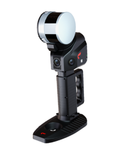
The SLAM100-YHS12C is a handheld LiDAR scanner with a 360-degree rotating head delivering 270 x 360 degree point-cloud coverage. Its industry-leading SLAM algorithm produces high-precision 3D point clouds (2 cm relative, 5 cm absolute) with automatic control-point collection, three 5 MP cameras for colour point clouds, and up to 2.5 hours of operation - effective even in GPS-denied environments.
- 270 x 360 degree FOV, 320 kHz, 120 m range
- 2 cm relative / 5 cm absolute accuracy
- Three 5 MP cameras (200 x 100 degree)
- Automatic control-point collection
- 2.5 h replaceable batteries
- UAV-mountable
Why the CHCNAV YHS12C SLAM Scanner
Advanced scanning solution
A 360-degree rotating head offers 270 x 360 degree point-cloud coverage, ensuring comprehensive data collection.
Precision and accuracy
An industry-leading SLAM algorithm ensures high-precision 3D point clouds with 2 cm relative and 5 cm absolute accuracy, plus automatic control-point collection for easy georeferencing.
Durable and portable
An integrated design with built-in control and storage and replaceable lithium batteries provides up to 2.5 hours of continuous operation.
High-resolution cameras
Three 5-megapixel cameras capture detailed texture for colour point clouds and partial panoramic images.
Versatile connectivity
External interfaces connect to panoramic cameras, GPS modules, UAVs and vehicles, with the SLAM GO mobile app and SLAM GO POST PC software for processing.
Key specifications
- FOV 270 x 360 degrees, 320 kHz, 120 m range
- 2 cm relative / 5 cm absolute accuracy
- Three 5 MP cameras (200 x 100 degree)
- 2.5 h battery life
Interested in the CHCNAV YHS12C SLAM Scanner?
Request a quote or ask us for advice on the right configuration for your application.
Get a quote