CHCNAV Alpha3D Mobile Mapping
Vehicle-independent mobile mapping platform
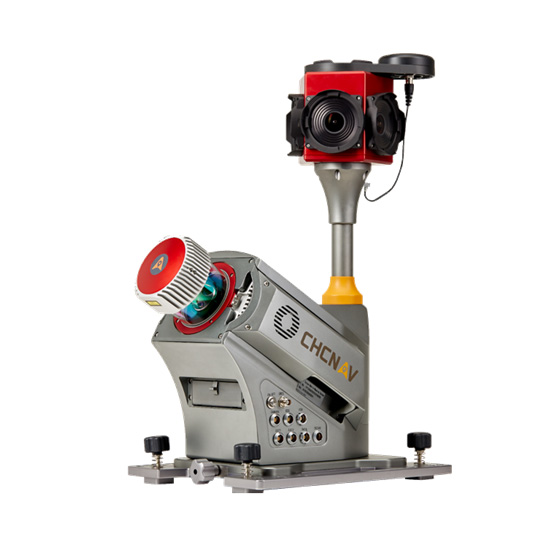
CHC Alpha3D is a vehicle-independent mobile mapping platform that combines a Riegl VUX-1HA laser scanner, a FLIR Ladybug5+ 360-degree spherical camera, a KVH1750 IMU and a NovAtel ProPak6 GNSS receiver into an extremely robust and efficient solution for corridor, city, rail and mining mapping.
- 2-3 cm absolute / 5 mm relative accuracy
- 235 m range (420 m max), 1 M points/s
- Synchronised point cloud + panorama imaging
- IP64, 19 kg lightweight unit
- Vehicle-independent, upgrade-ready
Why the CHCNAV Alpha3D Mobile Mapping
High accuracy
2-3 cm absolute system accuracy and 5 mm scanner relative accuracy with low range noise, using best-in-class GNSS and IMU units.
Every detail in focus
A combination of high-density point clouds and high-resolution panorama images, precisely synchronised to each other.
Dominant performance
A 235 m scanning range (420 m max), 1 million points per second scanning speed and 250 Hz scanner rotation speed.
Robust and lightweight
IP64-rated, operational across a wide temperature range, a 19 kg unit with an optional 16.6 kg roof-rack extension, and ready for future upgrades.
Powerful software
CoCapture software for data acquisition and the CoProcess package for processing, with export to LAS, PTS and other formats.
Key specifications
- 2-3 cm absolute, 5 mm relative accuracy
- 235 m range (420 m max), 1 M pts/s
- 250 Hz scanner rotation
- IP64, 19 kg
Interested in the CHCNAV Alpha3D Mobile Mapping?
Request a quote or ask us for advice on the right configuration for your application.
Get a quote